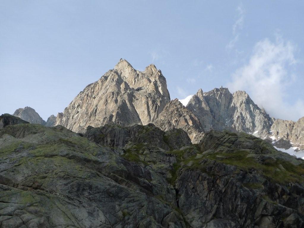
Eiger Nordwand
Eiger Nordwand from caroline george on Vimeo.
While growing up, I had heard of the infamous Eiger North Face, but I’ll confess, it was mostly just some mythical mountain that I knew nothing about. While in college I remember a friend telling me they had visited Switzerland and looked “down” on this face (presumably from the tunnel window). Being a climber I casually mentioned how I wanted to go climb that one day – still knowing nothing of what my statement entailed. I was quickly told it was impossible and I would never be able to do it… “You don’t understand”, exclaimed my friend there is rock, snow, ice, even waterfalls on this face it is just unclimbable. That was all I needed, while I nodded in agreement this was a challenge I couldn’t ignore and in my mind it was settled – I would go climb the Eiger North Face someday.


- The famous Eiger tunnel and the start of our approach (the descent comes down the West Flank just behind/above the tunnel)

Three and a half years ago a friend and I flew to Switzerland to attempt the Eiger. We had heard the conditions were great, so we bought last minute plane tickets and set off. As it turned out, the conditions “were” great , but it had been snowing non-stop for nearly three weeks now and conditions were no longer good. While we did start the climb, our attempt was short lived. We were turned around only an hour into our climb by deep unconsolidated snow, but nonetheless, the hook had been set and for the past three and a half years this face has always occupied a place somewhere in the back of my mind.
Since my first attempt, I have read a lot of the classic litterature written about the face, seen the recent movies produced about the mountain and to top it off, even kept a link on my favorites page to the North Face webcam. I guess to some degree I was getting a little obsessive about this climb. I had spent plenty of time in Europe over the past few years, but this climb seemed to always elude me – good conditions, but no time to climb (or vise versa), bad weather, or no partner. I had even guided the Eiger on a couple of occasions via different ridges, but there was always something keeping me from a second try at the North Face.

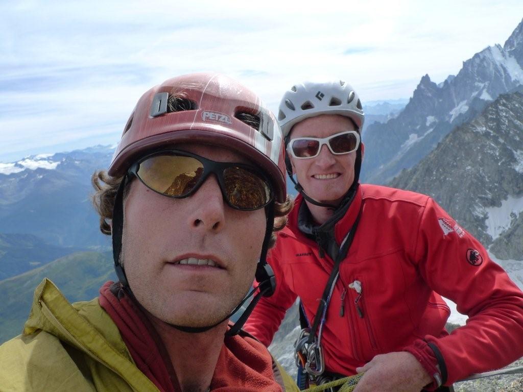
Last week however, I got my chance. I had time off, was well acclimatized and fit after a summer of guiding, the weather looked perfect, and a call to Grindelwald revealed the conditions looked great – although nobody had been up there to confirm. I was able to convince a fellow American guide and friend of mine, Tim Connelly, to head over and have a go. I’ll admit, I wasn’t entirely optimistic and even brought an extra bag along with some sport climbing gear just in case we got shut down.

We left Chamonix at 4am with plans to catch the first train and exit just before the train enters the famous Eiger tunnel. From this position it is an easy 30 minute approach and your standing at the base of perhaps the largest face in Europe. We planned on the climbing the 1938 first ascent route in two days spending a night at the infamous “Death Bivouac”. Despite some wrong turns on our drive to Grindelwald, we managed to catch the first train at around 7:30 and we were on our way.

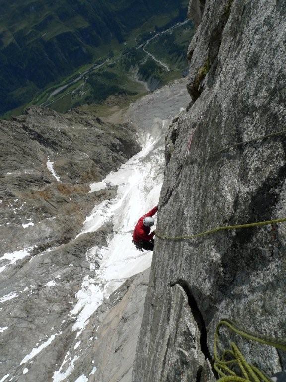
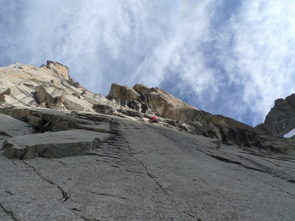
If I could describe the route in one word I would have to call it an Odyssey. Upon hiking to the base you are greeted with a couple of memorial plaques – not the most comforting of omens – and thus the journey begins. The route finding initially is very tricky and you meander through lines of weakness up some improbable looking terrain. Initially the rock was dry but quickly snow and ice appeared on ledges and we were forced to wear crampons. The first landmark on the route is the “Difficult Crack,” but arriving here wasn’t as straight forward as we had hoped. In fact, we did quite a bit of climbing just to arrive at this feature and some of it seemed even “more difficult”…?
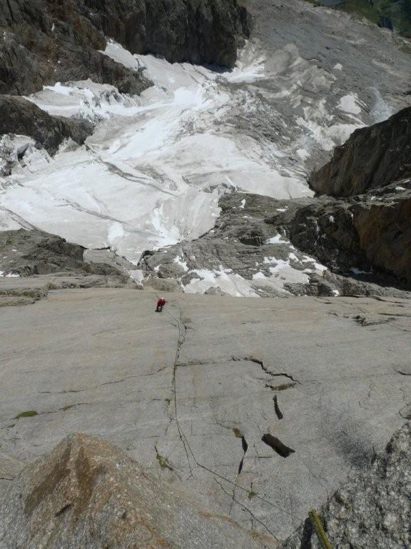
From here the route finding becomes more straight forward – even more so considering there were teams in front of us putting a track in the snow – and we progressed upwards almost as if climbing back through history. We passed many of the famous pitches and landmarks including: the Hinterstoisser Traverse, First snow field,the Swallows Nest, the Ice Hose, second snow field and then finally arriving at the Death Bivouac. We enjoyed excellent conditions on the face and the climbing was never too difficult and we covered a lot of ground.
The night we spent on the face was very special for me and something I will remember for a long time. Spending a night on one of the most historic faces in the world complete with all the triumph and tragedy associated with it, was a very touching experience. The weather was perfect and we watched a great sunset, ate some soup and slept at one of the best bivy spots I have ever enjoyed.
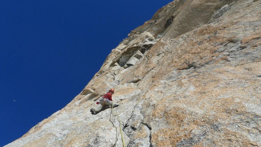
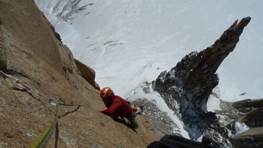
The second day began with a traverse into the Ramp where the real climbing began. We did several pitches up this feature involving a lot of mixed climbing, awkward squeezes and some pretty scrappy ice climbing. This section of the climb reminded me of Colorado’s well known ice climb “Bird Brain Boulevard,” except this was really just the start of our day. Next we climbed up through the Brittle Ledges and Brittle crack to the notorious “Traverse of the Gods.” I had heard a lot about this section of the route and I’ll be honest I was a bit nervous about this part of the climb -a 150m snow and rock traverse which is offers tons of exposure and very little in the way of protection.

Luckily this section, while exciting, was never very difficult and allowed us relatively quick passage to the famous “white spider” and finally the exit cracks. Again, the upper part of the route has a reputation for some difficult climbing and we were not let down. The “Quartz crack,” while short, proved to be quite a challenge – rock climbing, ice climbing, dry-tooling even a little aid all used in about 20 feet – you gotta love alpine climbing.

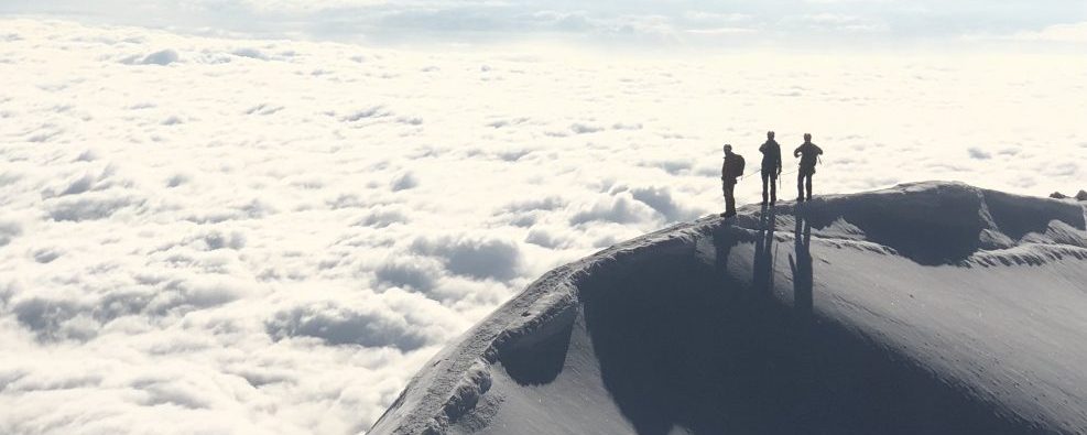
Upon exiting the “Exit cracks” you are soon on the upper snowfields, which take you to the Mitteleggi ridge and then to the summit. The final summit ridge is quite spectacular and certainly one of the most beautiful sections of ridge found anywhere in the Alps. We spent some time on the summit taking in the view and taking in the route we had just done. The Eiger is home to so much history and after climbing the face, following in the footsteps of so many legends, it’s hard not to feel in some small way like part of the history yourself. While I will never know what it was like to climb this route in 1938, I’ll be forever humbled by the courage, determination and talent displayed by its first ascent team. This is a roue that has stood the test of time and a climb that I will never forget!


What to do with time off?

In the guiding business, summer is a busy time. The old adage “make hay while the sun shines,” is a motto that most guides I know live by. It is not uncommon to work 20-30 days straight or even more. Nonetheless, no matter what the profession, we all need a break and some time off. Some people like sandy beaches and umbrellas in their drinks, others prefer cozy cabins and reading by a fireplace. Ironically, my “get away” from guiding in the mountains usually involves going back into them…
Our trip began at the Torino Hut on the Italian side of Mont Blanc. Located at around 3,600m this hut allows quick access to the Grand Capucin one of the most acclaimed formations for rock climbing in the Massive. After a good Italian meal and restful night of sleep, we set out at sunrise intent on climbing “Voyage Selon Gulliver”, a 400m route up the heart of the formation. This route was a break through when first established in 1982 and is still said to be one of the most classic lines in the range. Thanks to the lift systems in the Alps, the approach to our route was a mere one hour stroll across the glacier. We left the hut right at dawn despite high winds and cold temps. Upon arriving at the south facing wall however, the wind had died and it sun was already warming up the orange granite.
Indeed this route was a classic. A mix of face climbing connecting brilliant crack systems takes you more or less right up the center of this magnificent feature. This “mostly free” style is something I’ve grown increasingly fond of especially during the summer when my legs seem to grow and my arms shrink. In the end, who cares, as long as you’re enjoying yourself? In the end, that is exactly what we did. We moved quickly up our route and made it back well before the last lift. Yet, had I known this route was merely a warm up for what was to come I probably would have tried to slow the day down and miss the last lift.
After our climb we enjoyed a cold beer and discussed the following day’s options. Bertrand had heard of a route on the Italian side of the range, “Etoiles Filantes” on the Tour des Jorasses. This route, located on the southern shoulder of the famous Grandes Jorasses, was likened to the Grand Capucin but much more remote and “sauvage” (wild). He figured that since I am American, the long approach and likely no crowds would be right up my alley. Maybe I’m getting soft, I’m not sure, but there is a reason why I spend so much time in the Alps. I really like to spend my time climbing rather than approaching and the lift infrastructure in the Alps makes this very easy to do. Nonetheless, after another cold adult beverage I was easy to convince and, sometimes, it is good to approach the old fashioned, by foot.
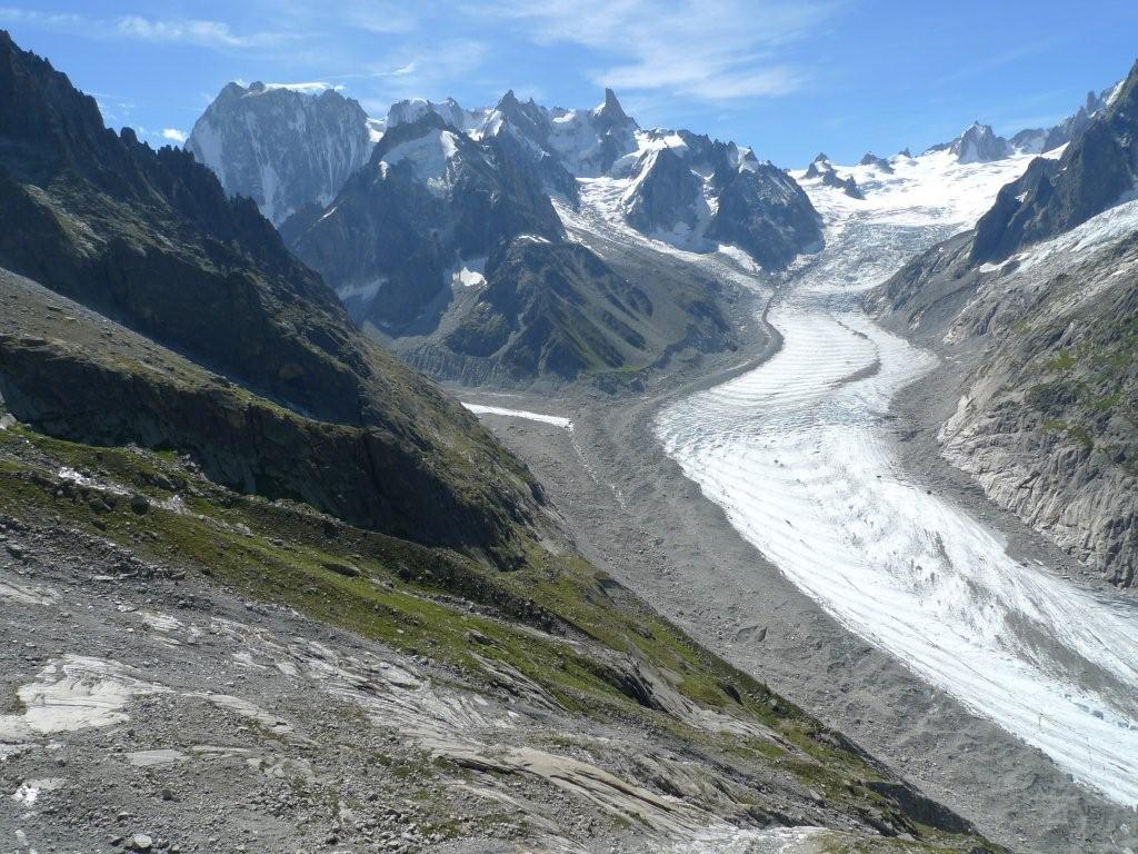
Day two didn’t begin quite as leisurely as our fist day had: our predawn start was followed by a 1700 vertical meters gain to reach the base of the route . The approach is steep and involves some interesting glacier navigation and, to top it off, one of the biggest seracs in the entire massif looms above the valley you ascend. Three and a half hours later we were at the base of the route and the real fun was only just beginning: 450 meters of granite awaited us.
The route we chose for the day was indeed a classic, but also quite sustained. This route, established by Michel Piola, perhaps one of the most prolific route setters of all time, takes a brilliant line up this majestic feature connecting crack systems via some very improbable slabs. Piola is known for his mastery of slab climbing and it seemed that he was in his prime when he created this gem. Bolts that were placed were done so quite conservatively, especially for Alps standards, that the climbing was quite engaged and committing.
Sometimes while rock climbing things just work out, the last piece of gear left on your rack is precisely the size you need, you find that key hold right in the nick of time, or in this case, I ended up with the pitches that suited me best with no premeditation (read: more gear, less scary). As it turned out on this route, Bertrand ended up with the hard slab pitches while I managed to get the hard crack pitches. Fortunately for me, I enjoy crack climbing and probably have the most experience with that, but on the other hand, nobody likes hard slab climbing. Bertrand, however, pulled off the difficult slab pitches flawlessly and our day went very smooth. We managed to get up and down the route and back down to Courmeyer in time to enjoy another nice Italian meal. After our 14 hr day and after logging nearly 900m of granite in the past two, it was time for Bertrand to go back to work, myself however, I still had two more days before I started working and the weather was still beautiful.
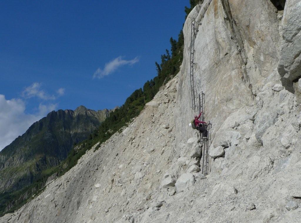
After a rest day, my wife joined me for one final mission. We chose a 300m route “La Reprise” on a formation known as the Flamme de Pierre noted as being a stunning crack climb. Our day began with a train ride and then required about an hour and half approach complete with descending a long series of ladders, crossing a glacier, ascending a long series of ladders, some steep hiking, an alpine meadow and a partridge in a pear tree. Once again, the granite in the Massif did not disappoint. The climbing was continuously steep and sustained up beautiful corner and crack systems with a backdrop that could not be beat. And, to top it off, there were no arguments ending in shouting or crying during our climb (okay, only someone who has climbed with their spouse will find this amusing).
We intentionally only bought one way train tickets as we were sure we wouldn’t make the last ride down. Not a big deal really, but it does add another hour and half to the descent. However, when we rappelled down to our packs, we had exactly one hour to catch the train so decided to give it a try. With a combination of running and speed descending/ascending ladders we arrived sweaty, tired but relieved to just catch the last train. A fitting end to a brilliant week of exploring some of the best granite in the range, physically exhausted but mentally refreshed to start work the following day.
The Bietschhorn

Once upon a time, the Bietschhorn was a 4000m peak. This mountain reigns proudly on the northern slopes of the Valais and is the only snowcapped mountain visible from anywhere in the Rhone Valley. Its the pride of the locals. So much so that on old maps, the Bietschhorn reached 4003m. This was thanks to a local Lotschental girl who seduced the geographer who had first measured this mountain into adjusting the elevation to a number greated than 4000m. When the correct altitude – 3934m – was finally put on the maps, the local wrote a threatening letter to the President of the Swiss Confederation, vouching that “The Bietschhorn was and would remain a 4000m peak!”
I first climbed this peak in 2005 during a Swiss Alpine Club training during which we climbed most of the routes one can access from the remote Baltschiederklause hut: The north ridge of the Bietschhorn, the south ridge of the Jaggihorn and the Arete Blanchet on the Lotschentaler Breithorn. I remember being blown away by this pristing remote valley, by the Chamonix like rock quality and last but not least, by the hut keeper’s yummy butter ladden cakes. I knew I would be back.
After the Meije traverse, I had hoped to take Flo on the Obergabelhorn-Zinalrothhorn traverse. Yet, recent storms had brought too much fresh snow at higher elevations. I suggested going into the Baltschieder Valley, which is at a lower elevation and south facing. She was excited to discover a new valley in her own backyard.
The hike to the hut first follows the Bisse de Undra. The southern slopes of the Bernese Alps drop so steeply into the V-shaped Rhone valley that they hardly ever see rain. The fields are therefore deprived of any humidity. As a result, the locals built and dug water runnels to get the water flowing from the glaciers all the way to the fields.


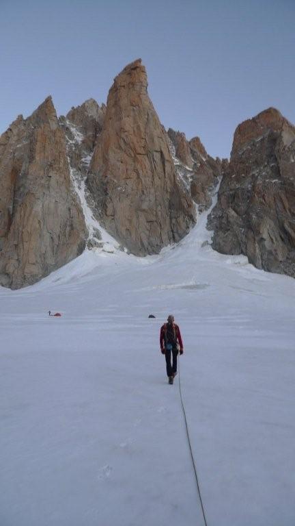
With 1850m of elevation gain, the hike to the Baltschiederklause hut is one of the longest hikes in the Bernese Alps. After the Bisse, the trail climbs to a little ghost village where we had a nice lunch before climbing steeply through fields and moraines to the hut. We arrived just in time to see the sun setting behing the following day’s climb -The Bietschhorn – and on the Mischabel range across the valley.


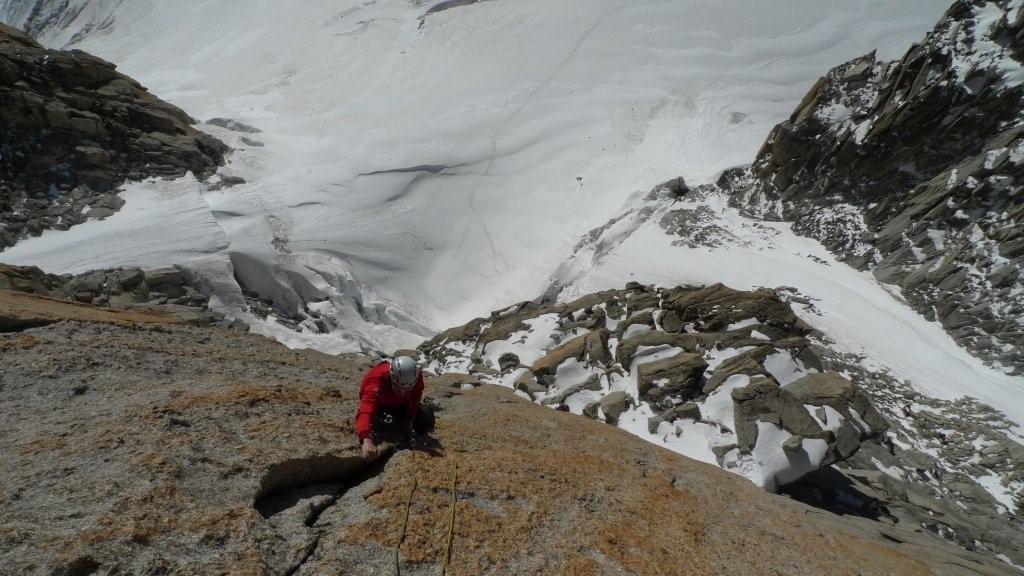
We woke up the following day to stars in the pitch dark sky. Following little dotted reflectors along the trail (Yup, that is Switzerland for ya!), we walked in the stilness of the night, with no one but us on the way. We reached the glacier by day break. We put crampons on and traversed the 2km long stretch of the Ausser Baltschieder glacier to the base of the North Ridge. After climbing up really poor rock and a 300m long snow/ice face, we reached the ridge proper: a snow and ice knife-edge ridge which leads to a more rocky ridge to the summit.


The view from the summit extends southward from the Monte Rosa to the Mont Blanc range and to the north to the Bernese Oberland (Eiger, Monch, Jungfrau). We climbed back down the way we came up and were back at the hut in the early afternoon, in time for a slice of straight-out-of-the-oven cake.


We woke up the following day to gray skies. We headed anyway, hoping that clouds would burn off as forecasted. The ascent starts litteraly five minutes from the hut and climbs up perfect granite. Half way up, we were caught by a snow storm and strong winds. By then, it would have been longer to go down than to keep going to the summit. The storm died a little and we reached the summit. A quick note in the summit book and we headed down, following cairns to the start of the 6x20m rappels back to the trail.


Again, we were back at the hut in the early afternoon, but we still had a long day ahead of us, having to hike back down to the car, 1850m below. We had a bite to eat and made our way down, marvelling at the surrounding summits and already dreaming of other climbs to guide in the area: The Arete Blanchet on the Lotschentaler Breithorn and the south ridge of the Stockhorn.